

Nossos serviços estão apresentando instabilidade no momento. Algumas informações podem não estar disponíveis.
-
Home

-
Geosciences
-
Territorial organization
-
Geographic networks and flows
- NP-Areas of Influence of Cities
Areas of Influence of Cities
Description
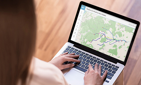
The survey Area of Influence of Cities - REGIC defines the hierarchy of the Brazilian urban centers and delimitates the areas of influence associated to them. It is in this survey that the Brazilian regional capitals and metropolises are identified as well as how far their spatial influence goes.
The identification of the urban hierarchy and influence areas is carried out by means of the classification of the urban centers that have certain equipment and services and that attract populations from other localities. The differentiated supply of goods and services among the cities makes populations move to well-equipped urban centers searching for health and education services or an airport, for instance. Tracing the relationships between the Brazilian cities based on the analysis of goods, services and management flows is an important tool for making choices concerning location, as the decision to where a university, a hospital or a comapany's branch should be.
About the publication - 1972
The study Division of Brazil into Functional Urban Regions is the first edition of the REGIC survey. It was released in 1972 based on questionnaires relative to year 1966. It is worth mentioning that the name Area of Influence of Cities was only adopted after the second edition, in 1987, but the overall nature of the study is the same.
A total 718 centers were identified in the four urban hierarchies, classified as: Level 1 – Heads of Urban Networks, Level 2 – Regional Centers, Level 3 – Sub-Regional Centers and Level 4 – Local Centers. That general classification has subdivisions that amount to a total 10 hierarchies.
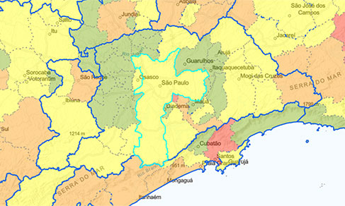
The database for the classification was a municipal enquiry filled out by the IBGE branches in 1966. Three steps led to the classification by hierarchical levels of urban centers and to the delimitation of their areas of influence. At the first step, the number of points obtained by each center in each one of the sectors (agricultural flows, distribution of goods and services to the economy and the population) were added to the total. At the second step, a hierarchy was established according to the total flows of each relationship matrix of municipalities. Finally, at the third step, the hierarchy and the subordination of centers were defined by the grouping of matrices according to the dominance of relations with metropolitan cities – nine previously defined Metropolitan areas – and the city of Goiânia, due to their extensive scope of action and its strong relationship with São Paulo and Rio de Janeiro.
It is worth highlighting this work is the consolidation of a sequence of studies inaugurated with the publication Preliminary sketch of the division of Brazil into homogenous spaces and polarized spaces, of 1967, and the chapter "Centrality" of the publication Subsidies to Regionalization, of 1968 - which made use of the same database as the questionnaires of 1967.
More on the product - 1972
Publication
Learn more - 1972
Downloads
News and Releases
IBGE surveys portray the Brazilian urban network for nearly six decades
The Brazilian Institute of Geography and Statistics releases this Monday the publication Regions of Influence...
16/12/2024

New module of the Interactive Geographic Platform calculates road, waterway and air distances between Brazilian municipalities
Starting today (Dec 6th), the IBGE will make available the reference base for road, waterway and air...
06/12/2022
IBGE launches interactive dashboard to help municipalities fight the pandemic
The IBGE launches today (21) the Covid-19 Dashboard by Municipality, with interactive maps that enable...
21/09/2020
REGIC 2018: Campinas/SP, Florianópolis/SC and Vitória/ES are now among the 15 Metropolises of the Country
Campinas/SP, Florianópolis/SC and Vitória/ES are now counted among the current 15 Metropolises. With...
25/06/2020
Campinas, Florianópolis and Vitória are the New Brazilian Metropolises
Between 2008 and 2018, Brazil had three new metropolises and 32 cities made into regional capitals in...
25/06/2020
Survey shows how people used to move around to go shopping before the pandemic
The IBGE releases today (21) the survey Areas of Influence of Cities (Regic) 2018 – Information on Trade...
21/05/2020
To prevent the spread of Covid-19, IBGE anticipates data on population access to health care
The IBGE anticipated for the Ministry of Health and the Oswaldo Cruz Foundation (Fiocruz) information...
07/04/2020
Errata
Change in the description of two variables in the "REGIC 2018 - Cities" database and change of a record in the "REGIC 2018- Population Arrangements" database of the Areas of Influence of Cities 2018
Published date: 09/10/2020
Description:
The description of the "REGIC 2018 Cities" database had the description of two variables inverted: VAR02, City area, was incorrectly described as Gross Domestic Product (GDP), whereas VAR03, GDP, was described as City area. Therefore, the "description of variables" spreadsheet was amended.In the “REGIC 2018 – Population Arrangements” database, the municipality of Fortaleza de Minas (MG) was associated with the Population Arrangement of Passos/SP, when the correct name of the unit is Population Arrangement of Passos/MG. That record in the table was amended.
Actions: The REGIC 2018 - Cities and REGIC 2018 - Population Arrangements were amended and replaced in the download area of the databases of the REGIC 2018 survey.
Links
FAQ
Does the survey REGIC define metropolitan areas?
The REGIC survey does not define metropolitan areas. In Brazil, the official metropolitan areas are established by a complementary state law.
On the other hand, REGIC identifies the Metropolises, which are considered the highest hierarchical level of the urban network. The concept of Metropolis at the REGIC refers to cities with a big population, which provide a great variety of services, a position of command in comparison with other cities – for the fact of housing companies and public institutions – and that attract populations from subordinate cities in search of goods and services. The Metropolises at the REGIC survey are presented with their area of influence, which are usually much bigger than a metropolitan area.
What is the periodicity of REGIC?
REGIC is conducted every 10 years. In the intervals, other thematic surveys in the segment of Networks and Geographic Flows take place, thus enabling a partial view of the changes in the urban networks between the releases of REGIC editions. Some examples are the studies entitled Air Links, Road and Waterway Links and the survey Territory Management.
What are ACPs?
Areas of Population Concentration.