

Nossos serviços estão apresentando instabilidade no momento. Algumas informações podem não estar disponíveis.
-
Home

-
Geosciences
-
Territorial organization
-
Territorial Meshes
- NP-Block-Face Database for Brazilian Addresses
Block-Face Database for Brazilian Addresses
Description
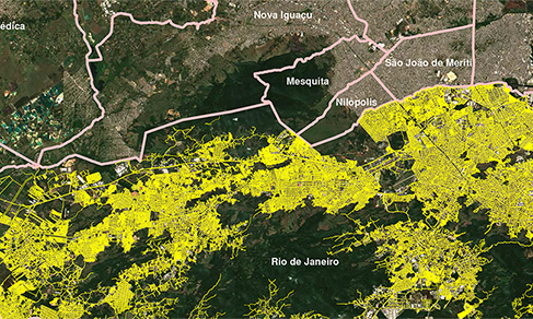
It is a geospatial database of lines that graphically represent the streets of urban areas, urban extension and rural agglomerations of Brazilian municipalities. In addition to the graphic information, there are attributes that refer to the name of the addresses, the territorial structure and the National Address List for Statistical Purposes – CNEFE. The Block-Face Database is fully updated at each Population Census and, between Censuses, it undergoes a continuous and cumulative process of specific updates in accordance with the progress of the institute's surveys and in accordance with specific field campaign actions carried out by teams from the Collection Network in the Agencies of the State Branches of the IBGE. In the current version, it reaches 13,688,342 line segments corresponding to block-faces, represented as a fundamental source for portraying the Brazilian territory and reflecting on its dynamics, supporting decision-making and the implementation of public policies with greater efficiency.
It is used by the IBGE to plan and carry out Census data surveys and Statistical Surveys such as the Continuous National Household Sample Survey - Continuous PNAD and the Consumer Expenditure Survey - POF, among others, covering all Brazilian municipalities, especially their cities and villages.
The construction of this database began with the migration of data from the 2007 Census (Census of Agriculture and Population Count), plus vector data through agreements with city halls and/or hiring of private companies, 2010 Population Census, 2017 Census of Agriculture and specific updates based on field surveys for the National Household Sample Survey, unifying the mapping used in these operations. These data were originally produced from different data sources, including cadastral mapping at different reference scales that have been adjusted, as available, to the geometries of high spatial resolution images, constituting precious elements in combination with the Mesh of Enumeration Areas.
About the publication - 2020
As an intermediate product, i.e., published between census operations, it neither includes statistical information of household types nor it shows the same updating degree of a Population Census.
It should be highlighted that the processes performed by the IBGE teams changed a lot over recent years, allowing to localize and extract data directly through APIs of either orbital or aerial ortho-rectified images available in the archives of the Directorate of Geosciences - DGC, aiming at maintaining the integrity and affinity with these reference images, i.e., creating better conditions of visual detailing and georreferencing of the geometry of the stretches of the road network.
Even so, some data produced may show imperfections occasionally in the geometric conditions, in georreferencing and in topological rules, like faces with inconsistent and noncontiguous extensions and azimuths, faces without connectivity and lacking nodes.
The Block-face Database for Public Areas represents, ultimately, the urban street layout of the Municipalities plus toponymic information. It is expected that the records now released are of great value for analyses on the spatial distribution, organization patterns and dynamics of changes in the urban areas of the Brazilian municipalities, considering an increase of 0.4% in relation to the previous version of 2019.
More on the product - 2020
Learn more - 2020
Quantitativos
- 5568 Municípios;
- 1 Distrito Federal (Brasília – DF);
- 1 Distrito Estadual (Fernando de Noronha – PE);
Arquivos – Formatos e atributos
A Base de Faces de Logradouros 2020 está estruturada por Municípios, em arquivos vetoriais no formato shapefile (SHP), compatíveis com utilização em diversos Sistemas de Informação Geográfica – SIG, organizados em pastas contendo para cada um os seguintes campos de atributos:
| CAMPO | TIPO | TAMANHO | DESCRIÇÃO |
|---|---|---|---|
| CD_SETOR | C | 15 | Identificação do Setor |
| CD_QUADRA | C | 3 | Número da Quadra |
| CD_FACE | C | 3 | Número da Face |
| NM_TIPO_LOG | C | 20 | Tipo do segmento do Logradouro : RUA, AVENIDA, TRAVESSA, etc... |
| NM_TITULO_LOG | C | 30 | Título do segmento do Logradouro (Almirante, Visconde, etc): ABADE ABADESSA ACADEMICO, etc. |
| NM_NOME_LOG | C | 60 | Nome do segmento do Logradouro |
| TOT_RES | N | 3 | Total de espécie residencial |
| TOT_GERAL | N | 3 | Total de espécies |
Referências Geodésicas e Cartográficas
Esta versão da Base de Faces de Logradouros está condicionada à Malha de Setores Censitários publicada em 25/02/2021 e à divisão política administrativa da Malha Municipal Digital publicada em 01/03/2021, também produzida anualmente pela Coordenação de Estruturas Territoriais da Diretoria de Geociências do IBGE.
A Base de Faces de Logradouros utiliza como referência geodésica e cartográfica o Sistema Geográfico não projetado ou Sistema de Coordenadas Lat. / Long. com codificação de texto – UTF 8. Este sistema, por não ser uma projeção cartográfica, não tem parâmetros, mas apenas a definição do sistema geodésico de referência.
Com relação ao sistema geodésico de referência, o Datum Horizontal utilizado é SIRGAS - Sistema de Referência Geocêntrico para as Américas (SIRGAS), em sua realização do ano de 2000 (SIRGAS2000), conforme Resolução da Presidência do IBGE Nº 1/2005 e Nº 1/2015, disponíveis em https://www.ibge.gov.br/geociencias/informacoes-sobre-posicionamento-geodesico/sirgas/16691-projeto-mudanca-do-referencial-geodesico-pmrg.html?=&t=resolucoes-e-legislacao.
A Malha Censitária disponibilizada é compatível com escalas de 1:5.000 a 1:25.000, sem supressão de pontos, de acordo com critérios técnicos preestabelecidos pela IBGE/DGC/CETE.
Destaque Quanto à Qualidade, Uso e Escalas
A Base de Faces de Logradouros está em escala cadastral, é compatível aos insumos adotados na geração progressiva da sua construção, e também, às atualizações promovidas entre 2011 e 2020. Apesar de esta base ter sido georreferenciada utilizando imagens disponíveis, podem haver discrepâncias posicionais em relação ao mundo real em algumas áreas do território.
Os atributos que compõem a Base de Faces de Logradouros podem, ocasionalmente, apresentar incoerências no seu conteúdo, como nomes diferentes para trechos de faces de um mesmo logradouro, nomes desatualizados ou mesmo falta de nomes.
Os logradouros são atualizados, conforme os critérios de amostragem adotados nas pesquisas demandantes, abrangendo, nessa cobertura, tanto as áreas urbanas quanto as áreas rurais, inclusive os aglomerados subnormais, povoados, lugarejos e núcleos, bem como, áreas de expansão urbana e de difícil acesso, onde o registro de endereços tende a ser frágil e não formalizado.
Não são divulgados elementos que possam identificar o informante ou caracterizar domicílios segundo o seu estado de ocupação. Na grande maioria dos aglomerados subnormais os logradouros não apresentam divisão de quadra ou face.
Todas as observações relacionadas com a qualidade dos dados citados neste documento são de conhecimento do IBGE, sendo que o mesmo não se responsabiliza pela correção destas imperfeições e nem de outras porventura existentes. O usuário ao utilizar esta base de dados deve estar ciente dessas observações, cabendo a ele a decisão de utilizar os dados da maneira que se encontram disponibilizados.
Almeja-se que esta divulgação estimule a atualização de registros, permitindo não só a realização de comparações, como também eventuais correções e possíveis incorporações de dados de outras fontes. A padronização do registro de endereços é fundamental para que as parcerias alcancem sucesso. A partir dela será possível dispor de dados mais consistentes para fundamentar a tomada de decisões e a implementação de políticas públicas com maior eficiência.
News and Releases
Block-Face Database grows 31% from 2010 to 2021
The IBGE launches today (Dec 15) the 2021 Block-Face Database in digital format. The product consists...
15/12/2022
Block-face Database for Public Areas increases 29% between 2010 and 2020
The IBGE publishes today (13) the Block-face Database for Public Areas 2020, which encompasses urban...
13/07/2021
Errata
Calendar error in release "2022 Population Census: Block-Face Database for Brazilian Addresses"
Published date: 12/04/2024
Description
Error characterized for not meeting the release date of the product, according to calendar released in December 2023. The product was delayed due to the need to reprocess the lines representing the block faces, due to inconsistencies found in the consolidation of the basic inputs.Therefore, the release of the 2022 version of the product Block-Face Database for Brazilian Addresses, was postponed from April to June 2024.
Actions: The release calendar has been changed.