

Nossos serviços estão apresentando instabilidade no momento. Algumas informações podem não estar disponíveis.
-
Home

-
Geosciences
-
Territorial organization
-
Territorial typologies
- NP-Urbanized Areas
Urbanized Areas
Description
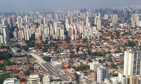
The urbanized areas of Brazil result from the mapping of the urban sprawl in Brazilian cities with the objective of monitoring the process of urbanization of the territory. The mapping of urban sprawl based on the use of satellite images creates a vector layer that delimitates the constructed areas in Brazilian cities. That is a growing demand from society and from the government in an attempt to understand the history of expansion of cities and the geographic dynamics now in progress in the Brazilian territory. The current mapping provides input for the classification and ordering of land, thus contributing to create a national view of issues related to the urban space.
About the publication - 2015
The Urbanized Areas 2015 project aims at providing an overview of the urbanization process in Brazil through the mapping (vectorization) of urbanized areas from satellite images. Pioneered by the IBGE in 2005, this initiative returns today aligned with the needs of the Sustainable Development Goals, particularly the SDG 11 of the 2030 Global Agenda, as well as of the New Urban Agenda, established by the Third United Nations Conference on Housing and Sustainable Urban Development - Habitat III.
This publication includes a methodological report with the objectives and operational procedures adopted, both in the identification of the urbanized areas in Brazil and in the classification and calculation of their areas. It also presents the first results, related to the urbanized areas of the Urban Concentrations in Brazil above 300 thousand inhabitants, as well as to the municipalities of Palmas (TO) and Boa Vista (RR). Such mapping will eventually include the urbanized spots of urban concentrations with a smaller demographic size.
Major technological advances, allowing a more accurate mapping of the urbanized spots in Brazil, took place between the release of Urbanized Areas 2005 and that of Urbanized Areas 2015. The project aims at providing a perspective of the Brazilian urbanization, in order to complement studies on the urban form and its regional distinctions, on the influence of the physical environment (topography, rivers, etc.) on the conformation of urbanized areas, as well as studies on the identification of trends and potential vectors of expansion of cities.
The results of this mapping provide inputs for the analysis of land use, giving and overview of the stage of the Brazilian urbanization in the first half of the 2010s. Every area in this study was mapped with the same methodology. Images from 2011 to 2014 in the 1:50,000 scale of the RapidEye satellite were used. The polygons of the urbanized areas were classified into two categories: dense and less dense. The dense areas show a continuous urban occupation, with small spacing between the constructions and higher capillarity of thoroughfares. Urban forms can be noticed in less dense areas, though with a more spaced occupation. This classification includes allotments still under construction and areas located in the outskirts of dense spots, characterizing a transition between the rural and urban landscape or even small isolated occupations, like, for example, headquarters of municipal districts.
More on the product - 2015
2015 Urbanized Areas - Online application
Access here2015 Urbanized Areas - Database
Publications - 2015
Áreas urbanizadas do Brasil : 2015
Material type: Book
Year: 2017
Learn more - 2015
Downloads
News and Releases
Southeast concentrates more than one third of urbanized areas in Brazil
In 2019, Brazil had 45,945 km2 of urbanized areas, the equivalent to 0.54% of the Brazilian area. More...
23/11/2022
Errata
Replacement in the Map of Urbanized Areas 2015
Published date: 02/07/2019
Description:
Replacement of Map 13 - Urbanized areas of Urban Concentrations of "Piracicaba/SP", "Campinas/SP", "Americana - Santa Bárbara d'Oeste/SP" and "Jundiaí/SP", SP due to an inversion in the toponym of a dam called Represa do Salto Grande.Actions: The document was corrected and replaced on the IBGE website.
Replacement of the Complete Publication in PDF format of the Urbanized Areas 2015
Published date: 02/02/2018
Description: Modification of legends in pictures 1, 2, 3, 4, 5, 6, 7, 8 and 9 of 'Elaborated by the Geography Department of the IBGE based on an image captured from Google Earth in 2017' into 'Elaborated by the Geography Department of the IBGE based on an RapidEye images for the period 2011 - 2014'.
Actions: The file was amended and replaced on the portal.
Substituição da base de dados das Áreas Urbanizadas 2015 (2)
Published date: 01/02/2018
Description: Modification in the nomenclature of Table 1 (formats .ots, .xls and .xlsx), in the momenclature of the shapefile and in the file 'LEIA-ME' (.txt). Modification in the title of Mapa00_AreasUrbanizadas2015_Brasil.pdf and in Mapa01_BoaVista_Macapa_Belem_Manaus_RioBranco_PortoVelho. Standardization of map resolution.PDF. Modification in Table 1 in the values of urbanized areas
FAQ
What are Urbanized Areas?
The Brazilian Urbanized Areas result from the mapping of the urban spots of the Brazilian cities and aims at monitoring the urbanization steps in the Brazilian territory.
Which are the differences between the 2005 and 2015 mapping?
The differences regard methodologies and inputs, besides the different set of municipalities involved. The 2005 Urbanized Areas, for example, were based on the CBERS-2B satellite images scaled 1:100,000, while the 2015 Urbanized Areas were based on RapidEye satellite images with spatial resolution of 5 meters on a sacle of 1:50,000 or less.
What period do the images cover?
The images used as basis for the 2005 Urbanized Areas mapping cover the years 2005 and 2007. Regarding the 2015 Urbanized Areas, the satellite images cover the period from 2011 to 2014.
Your question was not answered here?
Please contact us through our service channels.