

Nossos serviços estão apresentando instabilidade no momento. Algumas informações podem não estar disponíveis.
-
Home

-
Geosciences
-
Territorial organization
-
Territorial typologies
- NP-Urbanized Areas
Urbanized Areas
Description
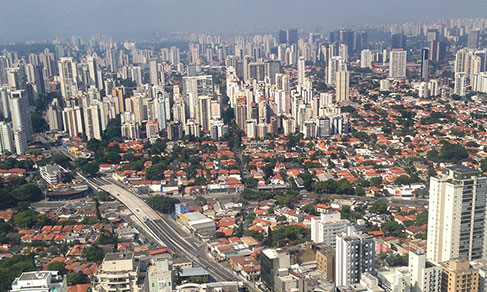
The urbanized areas of Brazil result from the mapping of the urban sprawl in Brazilian cities with the objective of monitoring the process of urbanization of the territory. The mapping of urban sprawl based on the use of satellite images creates a vector layer that delimitates the constructed areas in Brazilian cities. That is a growing demand from society and from the government in an attempt to understand the history of expansion of cities and the geographic dynamics now in progress in the Brazilian territory. The current mapping provides input for the classification and ordering of land, thus contributing to create a national view of issues related to the urban space.
About the publication - 2005
IBGE makes available for download the product Urbanized Areas of Brazil – 2005. This work results from the mapping (vectorization) of the urbanized areas based on images form the CBERS-2B satellite, on a 1:100,000 scale. The aim is to portray the urbanization stage of the Brazilian territory back in the 2000s. Most of the images that were the basis of the mapping are from the period between 2005 and 2007.
The urbanized spots were classified in three categories: very dense, dense e little dense. The very dense spots usually correspond to central areas of great urban agglomerations, characterized by a sharp density of constructions, with presence of verticalization and almost absence of non-impermeabilized soil. The spots classified as dense, in turn, are defined by a continuous urban occupation, low verticalization, with prevalence of houses, little space among the constructions, but with a greater presence of non-impermeabilized soil. Finally, the spots classified as little dense are characterized by the presence of urban features (streets, blocks, etc.), but scattered occupation. The little dense spots can represent settlements still being occupied or a transition between the urban and rural landscapes, usually located on the edge of the dense spots. There are also cases in which little dense spots are found in small, isolated occupations as, for example, municipal district headquarters.
The product is divided into three sets:
a) Urbanized areas of the great Brazilian urban agglomerations:
Such a set was used as the classical urban unit in the survey Areas of Influence of Cities – REGIC (2007). Those units aggregate all urban agglomerations or isolated municipalities with population above 350 thousand inhabitants in the year 2000 and were determined based on criteria of territorial cohesion, measured through people's commute to work and school (2000 Population Census), and through the conurbation of urbanized areas.
b) Urbanized spots of the Municipalities of the Coastal Zone of Brazil.
In this set are mapped out the urbanized spots of the coastal municipalities as defined by the Appendix A of the National Plan of Coastal Management II (Law 7,661 of 05/16/1988). Those spots were used in maps of the Geographic Atlas of the Coastal and Ocean Zones of Brazil (IBGE, 2011), depicting the urbanization status of the Brazilian coastal zone.
c) Urbanized spots of the municipalities with more than 100,000 inhabitants.
In this set, urbanized spots of the municipalities with more than 100,000 inhabitants were vectorized, according to the population estimate carried out by do IBGE for the year 2005.
It is worth mentioning, at last, that the repetition of some polygons occurs whenever a municipality belongs simultaneously to more than one set.
More on the product - 2005
Major Urban Concentrations 2005
Access hereMunicipalities with more than 100,000 inhabitants 2005
Access hereCoastal municipalities 2005
Access hereAplications
Databases and tables
Maps
- Urbanized areas - Major urban concentrations
- Urbanized areas - Municipalities with more than 100 residents
- Urbanized areas - Coastal municipalities
Learn more - 2005
Downloads
News and Releases
Southeast concentrates more than one third of urbanized areas in Brazil
In 2019, Brazil had 45,945 km2 of urbanized areas, the equivalent to 0.54% of the Brazilian area. More...
23/11/2022
Errata
Replacement in the Map of Urbanized Areas 2015
Published date: 02/07/2019
Description:
Replacement of Map 13 - Urbanized areas of Urban Concentrations of "Piracicaba/SP", "Campinas/SP", "Americana - Santa Bárbara d'Oeste/SP" and "Jundiaí/SP", SP due to an inversion in the toponym of a dam called Represa do Salto Grande.Actions: The document was corrected and replaced on the IBGE website.
Replacement of the Complete Publication in PDF format of the Urbanized Areas 2015
Published date: 02/02/2018
Description: Modification of legends in pictures 1, 2, 3, 4, 5, 6, 7, 8 and 9 of 'Elaborated by the Geography Department of the IBGE based on an image captured from Google Earth in 2017' into 'Elaborated by the Geography Department of the IBGE based on an RapidEye images for the period 2011 - 2014'.
Actions: The file was amended and replaced on the portal.
Substituição da base de dados das Áreas Urbanizadas 2015 (2)
Published date: 01/02/2018
Description: Modification in the nomenclature of Table 1 (formats .ots, .xls and .xlsx), in the momenclature of the shapefile and in the file 'LEIA-ME' (.txt). Modification in the title of Mapa00_AreasUrbanizadas2015_Brasil.pdf and in Mapa01_BoaVista_Macapa_Belem_Manaus_RioBranco_PortoVelho. Standardization of map resolution.PDF. Modification in Table 1 in the values of urbanized areas
FAQ
What are Urbanized Areas?
The Brazilian Urbanized Areas result from the mapping of the urban spots of the Brazilian cities and aims at monitoring the urbanization steps in the Brazilian territory.
Which are the differences between the 2005 and 2015 mapping?
The differences regard methodologies and inputs, besides the different set of municipalities involved. The 2005 Urbanized Areas, for example, were based on the CBERS-2B satellite images scaled 1:100,000, while the 2015 Urbanized Areas were based on RapidEye satellite images with spatial resolution of 5 meters on a sacle of 1:50,000 or less.
What period do the images cover?
The images used as basis for the 2005 Urbanized Areas mapping cover the years 2005 and 2007. Regarding the 2015 Urbanized Areas, the satellite images cover the period from 2011 to 2014.
Your question was not answered here?
Please contact us through our service channels.